The Science of Wildfire Spread: Factors Affecting Forest Fires and New Forestry Agencies Policy Measures
Field Footage: National Geographic explains the basic mechanics of how wildfires start, spread, and how forestry policies mitigate global destruction.
As global wildfire frequency continues to break records, understanding the science behind fire behavior and advocating for smarter government mitigation policies is the only way to safeguard our future.
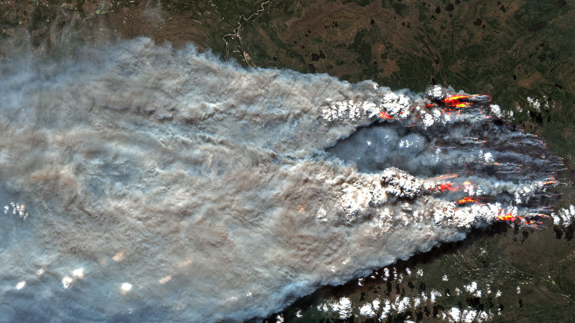
Satellite imagery capturing massive smoke plumes from an active wildfire spreading across a green landscape.
The Anatomy of a Wildfire: The Fire Triangle
At its core, fire is a chemical reaction. For a wildland fire to ignite and sustain itself, it requires three specific components to be present simultaneously. This is commonly known as the Fire Triangle:
- Heat: The ignition source. Roughly half of all wildfires are triggered naturally by lightning strikes, while the other half are human-caused (e.g., campfires, discarded cigarettes, equipment sparks, power line failures).
- Fuel: Combustible organic material such as dry leaves, grass, fallen branches, standing trees, and even deep underground peat layers.
- Oxygen: Provided naturally by the surrounding ambient air.
Preventing or extinguishing a fire requires removing at least one of these three elements. However, once a fire is sparked, it becomes a dynamic, living force. The way a fire burns and spreads over time is referred to as "fire behavior," which is heavily dictated by the surrounding environment.
The Three Main Factors Affecting Wildfire Spread
Understanding how a fire behaves requires analyzing the landscape it burns in. Wildfire spread, intensity, and direction are heavily influenced by three primary environmental variables: weather, fuel, and topography.
1. Weather and Climate (The Environment)
Weather is the most volatile and unpredictable variable in wildfire management. Hot, dry, and windy conditions act as a direct accelerant.
- Wind: High winds supply more oxygen to the flames, rapidly dry out surrounding vegetation, and can carry burning embers miles ahead of the main fire front, starting new "spot fires."
- Temperature and Humidity: Warmer temperatures pre-heat the surrounding fuels, making them easier to ignite. Low humidity extracts moisture directly from the vegetation, turning green flora into dry, highly flammable kindling.
Human-caused climate change is actively increasing the prevalence of "fire weather." Hotter daytime weather, earlier melting of winter snows, and notably warmer nighttime temperatures allow fires to persist and burn aggressively around the clock, whereas historically, fires would calm down overnight when humidity levels naturally rose.
2. Fuel Types and Density (The Forest Profile)
Not all vegetation burns the same way. The moisture content, size, and continuity of the fuel dictate how fast a fire moves.
- Surface Fires: Light, dry grasses and shrubs can cause surface fires to spread at incredibly rapid speeds—sometimes exceeding 12 km/h.
- Crown Fires: Dense, dry coniferous forests can sustain massive crown fires that leap from treetop to treetop. These fires carry extreme intensities, produce flames several times the height of the trees, and are generally uncontrollable by ground crews.
- Ground Fires: Deep organic layers, like peat and humus, can sustain smoldering ground fires that burn slowly underground. During intense droughts, these fires can smolder straight through the winter under the snow and reemerge the following spring (often called "zombie fires").
3. Topography (The Landscape Structure)
The physical shape of the land drastically alters fire behavior. Fires naturally spread much faster uphill because the heat from the flames rises, pre-drying and pre-heating the fuel directly above it. South-facing slopes (in the Northern Hemisphere) also receive more direct sunlight throughout the day, making the vegetation there significantly drier and more prone to combustion. Valleys and steep canyons can act like physical chimneys, funneling winds and dangerously intensifying the blaze.
Wildfire Containment & Air Operations
Simulate advanced fire dynamics including wind shifts and flying embers. Deploy ground crews to dig firebreaks or call in air tankers to drop retardant lines.
How Governments Can Take Measures to Prevent Wildfires
For decades, the standard governmental protocol for wildland management was aggressive fire suppression—putting out every single fire as quickly as possible. However, this well-intentioned strategy has inadvertently led to a massive, unnatural buildup of fuels in our forests. When a fire does ignite today, there is significantly more material to burn, leading to uncontrollable "megafires."
To combat this, governments worldwide are shifting their financial and operational focus from reactive firefighting to proactive prevention, land management, and risk mitigation. Here are the leading strategies and government measures being implemented today:
1. Prescribed Burns and Mechanical Fuel Management
One of the most effective ways to prevent catastrophic wildfires is to start smaller ones on purpose. "Prescribed burning" involves intentionally igniting controlled fires under highly monitored weather conditions. This clears out the dead underbrush, pine needles, and fallen branches that act as kindling for larger fires.
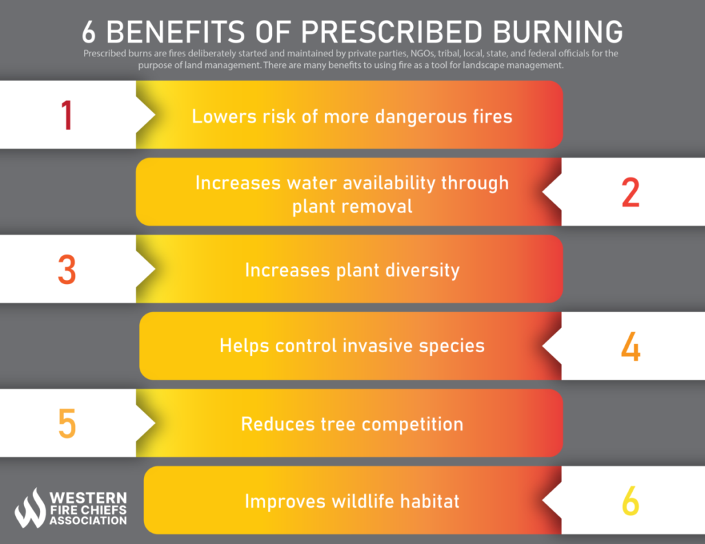
Figure 2: The ecological and safety benefits of prescribed burning operations, mitigating fuel overload.
Beyond prescribed burns, mechanical fuel treatments—such as thinning dense tree stands and physically creating "firebreaks" (wide gaps in vegetation that act as barriers)—are essential government tactics. These measures are especially critical at the wildland-urban interface (WUI), the boundary where natural vegetation meets human development, protecting homes, businesses, and essential infrastructure.
2. Leveraging Artificial Intelligence and Satellite Monitoring
Modern forestry agencies are increasingly relying on high-resolution satellite imagery and Artificial Intelligence to monitor dynamic vegetation changes. Instead of relying on static, outdated risk maps, governments use near-daily satellite data to see exactly where vegetation is drying out or where fuel loads are encroaching on power lines. AI algorithms process this massive amount of data to predict where a fire is most likely to start and how it might behave. By identifying specific high-risk zones, agencies can preemptively clear fuels or stage firefighting resources nearby before a fire even sparks.
3. Innovative Ignition Prevention Technology
Because lightning strikes account for roughly half of all wildfires, preventing the strike itself is a frontier technology in forest management. In 2026, the Canadian province of British Columbia initiated field trials with tech companies utilizing proprietary AI-enabled forecasting and targeted interventions designed to actually reduce cloud-to-ground lightning strikes in high-risk areas. Funding localized, made-in-house innovation allows governments to tackle natural ignition sources that were previously thought impossible to control.
4. Empowering Local and Indigenous Communities
Centralized government agencies cannot manage vast landscapes alone. There is a strong, growing movement toward funding community disaster resilience and supporting Indigenous-led fire management. Indigenous communities have utilized fire as a land stewardship tool for millennia. In Canada, recent ongoing funding has poured millions into First Nations communities to support mitigation, preparedness, and the hiring of dedicated Emergency Management Coordinators to suppress fires at the wildland-urban interface.
5. Stricter Regulations and Infrastructure Upgrades
Human activities—from unattended campfires to sparking power lines—are highly preventable ignition sources. Governments are responding by:
- Enforcing stricter burning bans during dry seasons and expanding surveillance to catch and control illegal agricultural burning.
- Working heavily with utility companies to harden infrastructure. This includes insulating overhead wires, actively clearing vegetation corridors, or burying power lines entirely in high-risk zones.
- Investing heavily in national aerial firefighting surge capacities to ensure planes and helicopters are ready to drop water and retardant the moment a fire is detected.

Figure 3: Smokejumpers and forestry teams managing fuel loads on the frontlines to prevent the uncontrollable spread of fires.
The Path Forward for Wildfire Resilience
The reality of living in 2026 is that wildfires are an inevitable part of our global ecosystems, exacerbated by a warming and changing climate. Wildfire smoke, filled with fine particulates and carbon monoxide, continues to pose severe health risks that cross international borders.
However, catastrophic destruction is not inevitable. By deeply understanding the dynamic factors that drive fire behavior—weather, fuel, and topography—we can outsmart the flames. Through a collaborative combination of ancient wisdom like prescribed burns, cutting-edge AI satellite monitoring, infrastructure hardening, and massive government investment in community resilience, we can shift the paradigm. We are no longer just fighting endless infernos; we are actively cultivating fire-resilient landscapes for the future.
Do You Live in a Wildfire-Prone Area?
Take action today by creating a 30-foot "defensible space" zone around your home. Clear out dead leaves, thin dry vegetation, and ensure your home's gutters are cleared. Small local changes save global forests!
Verified Fire Management registries
-
National Interagency Fire Center (NIFC):
https://www.nifc.gov/ The primary logistics and operational coordinating hub for wildland fire response management within the United States. -
U.S. Wildland Fire Service (Department of the Interior):
https://www.doi.gov/wildlandfireservice The unified federal agency platform addressing wildfire prevention, strategic suppression, and post-fire ecosystem recovery across public and tribal lands. -
NASA Applied Sciences — Wildland Fires Program:
https://appliedsciences.nasa.gov/what-we-do/disasters/fires Earth observation programs detailing active thermal dynamics, smoke progression, and carbon emissions modeling. -
NASA FIRMS (Fire Information for Resource Management System):
https://firms.modaps.eosdis.nasa.gov/usfs/map/ Near real-time active fire mapping layers fed directly from orbiting MODIS and VIIRS satellite instrument arrays.
Comments
Post a Comment